
LION CITY HUB • NATIONAL EDUCATION & HERITAGE
Bukit Merah Heritage Trail
Explore a district where an old hill legend, port activity and public housing meet.
The Story Behind the Red Hill
Bukit Merah means “red hill” in Malay and is closely associated with the well-known tale of Hang Nadim, the boy said to have saved Singapura from attacking swordfish. Beyond the legend, the wider district contains former villages, early housing estates and communities connected to Keppel Harbour.
Its landscape stretches from Redhill and Henderson to Telok Blangah and Tiong Bahru, showing how kampungs, industry and public housing were woven into Singapore’s urban growth. The Red Hill Legend adds another layer to the story. The tale of Hang Nadim explains the area’s name through a story of courage, cleverness and an unjust royal decision.
Harbour Communities shows how the area changed while retaining links to its past. Workers and families living near Keppel Harbour supported shipping, docks and industries along Singapore’s southern coast. Read together, these landmarks explain how community life, the built environment and national developments shaped Bukit Merah.
Did You Know?
Bukit Merah means “red hill” in Malay, a name linked to the traditional story of the clever boy Hang Nadim, and an important part of its local story.
The planning area includes historic neighbourhoods shaped by nearby Keppel Harbour, early industry and public housing, both historically and today.
What Makes Bukit Merah Special
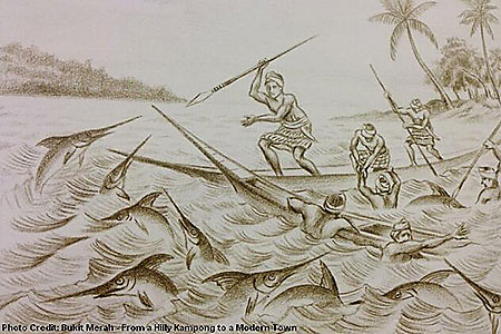
The Red Hill Legend
The tale of Hang Nadim explains the area’s name through a story of courage, cleverness and an unjust royal decision. Its story adds context to the district's changing landscape and community life.
Henderson Waves
Singapore’s highest pedestrian bridge is recognised for its wave-shaped timber structure and panoramic connection between Mount Faber and Telok Blangah Hill Park. It gives the area added character.
Keppel Harbour
The nearby harbour shaped work and settlement across southern Singapore, supporting dock labour, shipping services and industries that influenced Bukit Merah’s growth. It is still remembered.

Bukit Merah’s Lost Coastline
Before reclamation, the sea reached much closer to parts of Bukit Merah. Street patterns and older harbour communities preserve traces of this largely forgotten coastal landscape. It remains.
Trail Routes
Route 1: Faith & Multi-Religious Harmony
-
Duration: 1.5 hours on foot | Distance: 1.2 km
-
Focus: Trace South Bridge Road and Telok Ayer Street to observe Singapore’s religious co-existence, where Buddhist temples, Singapore's oldest Hindu temple, a Chulia mosque, and a Chinese Methodist church stand side by side.
Route 2: Early Immigrants & Street Life
-
Duration: 1 hour on foot | Distance: 900 m
-
Focus: Walk down Pagoda Street, Smith Street, and Sago Lane to discover the history of rickshaw pullers, Samsui women, high-density tenement living, and heritage street murals.
Route 3: Clans, Trade & Pioneer Leaders
-
Duration: 1.5 hours on foot | Distance: 1.8 km
-
Focus: Explore Bukit Pasoh Road, Club Street, and Ann Siang Hill—the historic strongholds of dialect clan associations, elite pioneer clubs, and traditional shophouse architecture.
